Talaat Harb Street
Virtual asset linked to this landmark

- Virtual owner
- The platform
- Times sold
- 0
- Fame on Wikipedia
- 5,609 article reads in 12 months
- Searches (30 days)
- 0
- Watching
- 0
Virtual ownership only. It gives no legal, financial or physical right in the real landmark. Prices are set by the market and may fall.
About Talaat Harb Street and its history
A main street in downtown Cairo.
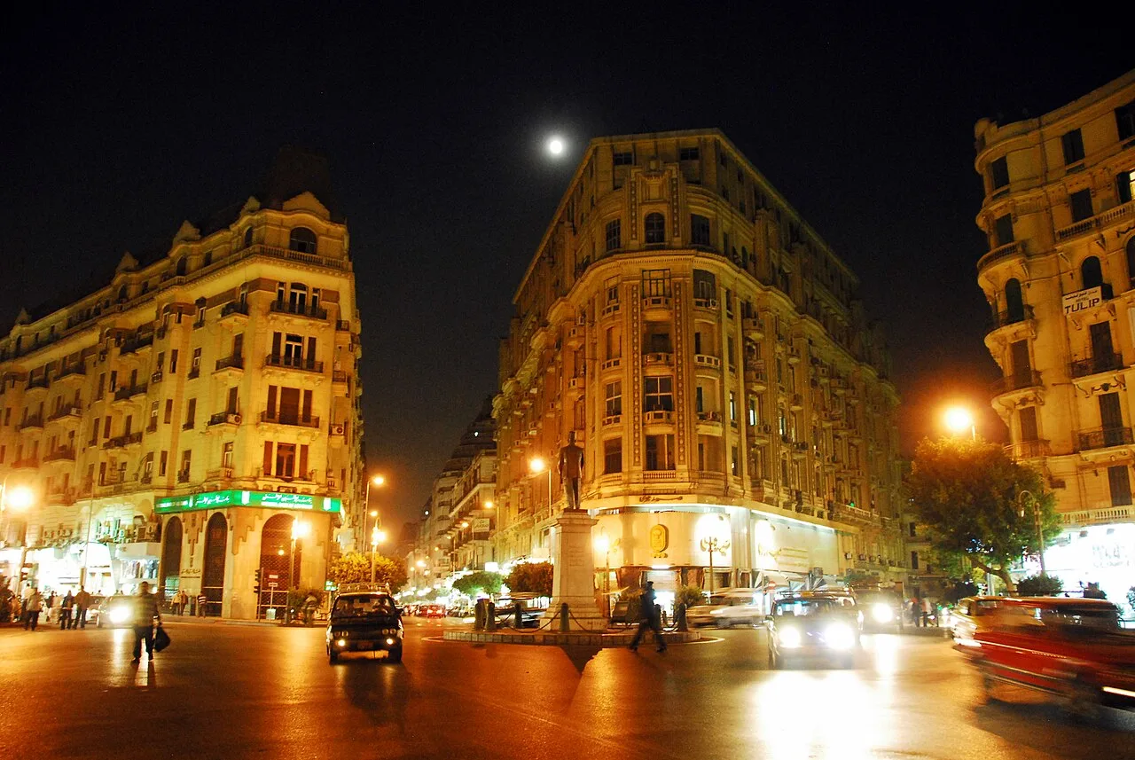
Talaat Harb Street (Arabic: شارع طلعت حرب pronounced [ˈtˤɑlʕɑt ˈħɑɾb]) is a historic street in downtown Cairo, Egypt, connecting Tahrir Square and Talaat Harb Square.
Naming
Originally it was named 'Soliman Pasha Street' after Suleiman Pasha, Egypt's French-born General under Muhammad Ali. The street was renamed in 1954 after Talaat Harb, the leading Egyptian economist of the early 1900s. The street received the 'Talaat Harb Street' name during a sweeping effort by Egypt’s new president, Gamal Abdel Nasser, to rid the city of all reminders of the Muhammad Ali dynasty and British occupation era.
Architecture
It is the historic architecture lining Talaat Harb Street that reminds visitors of its stylistic and eventful past. Until its name change in 1954, this avenue was named 'Soliman Pasha Street' and was a center for activity and social interaction among Cairo's upper and European classes. Although a remnant of its former 'Paris on the Nile' 19th century grace, the Midan Talaat, or Talaat Square, at the street's intersection with Qasr el-Nil Street is circled with buildings having the strong elegance of French neoclassical architecture from the Soliman Pasha era, and were once the locations of some of Cairo's most popular and successful shops and services.
Despite Nasser's attempt to mask colonial Egypt's history, done in the 1950s and 1960s, the structural design of the upper building facades on Talaat Harb Street is a reminder of a multi-colonial past. Various types of architecture representing different eras of Egyptian history are displayed on the floors above the new roughly redesigned yet inviting store facades on street level. Most of these buildings appear to be left over from the days of Khedive Ismail and his goal to create a new European inspired quarter in Cairo during the second half of the 19th century. He who stressed urban planning for the first time in Cairo, to include broad, linear gridded streets, open spaces and parks, geometric balance and harmony, and then modern European architectural styles. Yet the once grand appearance of these buildings has been lost to the clinging dust, battered shutters and general lack of outward upkeep. Interspersed between these sad structures are their modern counterparts, which appear significantly more aged than the actual date of the structure would suggest due to their hasty and incomplete construction. Identical glossy storefronts strung together along the street level provide a degree of continuity and collectively sacrifice the history disappearing above them for an eager pursuit of western culture and commerce.
Information source: Wikipedia · rewritten and edited by Maalem; available under CC BY-SA 4.0
- Location
- Cairo, Egypt
- Coordinates
- 30.0490, 31.2400
- Category
- Districts, Streets & Markets
Source: Wikipedia · Factual information about the real landmark; unrelated to virtual ownership.
Price & ownership history
Landmarks near Talaat Harb Street
Map → Available
📖 1 K reads
Available
📖 1 K reads
 Available
📖 7 K reads
Available
📖 7 K reads
 Available
📖 8 K reads
Available
📖 8 K reads
 Available
📖 84 K reads
Available
📖 84 K reads